$296,000
For more information regarding the value of a property, please contact us for a free consultation.
122 Acres Lot
SOLD DATE : 09/13/2024
Key Details
Property Type Vacant Land
Sub Type Recreational
Listing Status Sold
Purchase Type For Sale
MLS Listing ID 1987619
Sold Date 09/13/24
HOA Y/N No
Annual Tax Amount $22
Lot Size 122.000 Acres
Acres 122.0
Lot Dimensions 0.0x0.0x0.0
Property Description
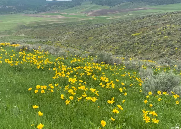
Soak in the views from this beautiful 122-acre mountain property. This property is about owning a legacy for your family and the freedom to enjoy the solitude of your own land. Located approximately 4 miles North of Clarkston's residential area on "The Loop." Ideal for dry farming, recreation, hunting, camping, ATVs, or snowmobiling. From the property's gate on Dirty Head Rd, travel on your private, one-mile dirt road East to the top of the mountain. The view from the top shows off Gunsite and Mendon Peaks to the West, Naomi and Logan Peaks to the East, overlooking Cache Valley from North of the Idaho border to Powder Mountain. The property is very private with a beautiful valley running down the middle. A small portion of land on the west side of the road has the Clarkston Creek running through it. No water rights, no utilities onsite, Dirty Head Rd is not maintained in the winter. 40 minutes to Logan or Preston, and less than an hour to Malad. Just over an hour to Ogden, and less than 2 hours to the SLC Int'l Airport. Lot lines shown are for illustration purposes only, Buyer to verify all information. **Schedule your private showing today! Access by appointment only.**
Location
State UT
County Cache
Area Cornish; Lwstn; Clrkstn; Trntn
Zoning Agricultural
Interior
Fireplace false
Exterior
Utilities Available Natural Gas Not Available, Electricity Not Available, Sewer Not Available
View Y/N Yes
View Valley
Present Use Recreational,Agricultural,Other
Topography Terrain: Flat, Terrain: Grad Slope, Terrain: Hilly, Terrain: Mountain, Terrain: Steep Slope
Private Pool false
Building
Lot Description Fenced: Part, Terrain: Grad Slope, Terrain: Hilly, Terrain: Mountain, Terrain: Steep Slope, View: Mountain, View: Valley, Terrain: Flat
Sewer None
New Construction No
Schools
Elementary Schools Lewiston
Middle Schools North Cache
High Schools Green Canyon
School District Cache
Others
Senior Community No
Tax ID 15-003-0006
Acceptable Financing Cash, Conventional
Horse Property No
Listing Terms Cash, Conventional
Financing Cash
Read Less Info
Want to know what your home might be worth? Contact us for a FREE valuation!

Our team is ready to help you sell your home for the highest possible price ASAP
Bought with NON-MLS
"My job is to find and attract mastery-based agents to the office, protect the culture, and make sure everyone is happy! "


